weather United States Ski Ward
  • 15 day forecast

    - -
  • Weather Saturday - -
Time / Hour

Today's Forecast

Régis CRÊPET

Forecast produced by Régis CRÊPET

Updated at - Next update at (local time)

In Short
avalanche risk 1
N.C.
expert La Chaîne Météo Expert’s summary

Tonight in Ski Ward, warning: winds gusting very strongly.
Temperatures will vary between -1 and 5°C, it will be cold in the morning.
The reliability of the situation is good.

This evening


Sleet showers becoming less frequent, or showers
Feels Like -5° due to the wind
Gusts 70 km/h W 30 km/h
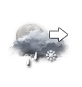
Very cloudy sky becoming more unsettled.
Light sleet.
Risk of rain 70 %
Freezing level 0°
0 m
Snow-rain limit
0 m
Fresh snow
0 cm

Night


Sunny periods
-3° Feels Like -8° due to the wind
Gusts 70 km/h W 30 km/h
Light passing clouds that do not interfere with the sunny weather.
Warning: conditions favourable to black ice.
No risk of rain
Freezing level 0°
0 m
Snow-rain limit
0 m
Fresh snow
0 cm

Station Info

open
Ski Ward
avalanche risk 1 Avalanche Risk
N.C.

Snow


152 cm at the top (128m)
60 cm down (64m)

Snowfall


9 months ago : 15.2 cm
10 months ago : 10.2 cm

Track Info


Lifts 3/4
Snow Parks -/1
Nordic ski N.C.
Back skiing N.C.

Open tracks


- 3
- 3
- 0
- 3
with ski info

Ephemeris


Friday 19 december

  • Day
    0 min
  • New
    Moon
  • Sunrise
    07h09
  • Sunset
    16h18
  • Anastasius I

Next few days


Points of interest arround Shrewsbury


Near Ski Ward