Tonight in Col De Rousset, Very cloudy. Showers becoming less frequent.
Temperatures will vary between 2 and 4°C, it will be cold and with values close to normal.
The reliability of the situation is relatively good.
This evening
3°Feels Like 1°
Gusts 40 km/hS 10 km/h
Very cloudy sky with short clear periods.
Light rain clearing gradually.
Risk of rain
100 %
Freezing level 0°
1900 m
Snow-rain limit
1600 m
Snow expected
0 cm
Night
2°Feels Like 1°
Gusts 25 km/hS 10 km/h
Overcast sky with a slight tendency to improvement.
Slight risk of showers.
Risk of rain
20 %
Freezing level 0°
1800 m
Snow-rain limit
1500 m
Snow expected
0 cm
Share
Station Info
open
Col De Rousset
Avalanche Risk
1/5 - Low risk
Snow
30 cm
at the top
(1700m)
0 cm
down
(1255m)
Snowfall
18 days ago : 95 cm 19 days ago : 35 cm 1 month ago : 10 cm
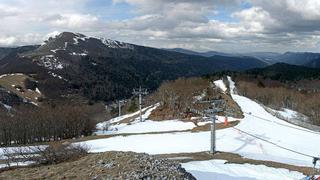
Webcam
"Col de Rousset - Front de NeigeYesterday
Col de Rousset - Front de Neige
Track Info
Lifts
8/11
Snow Parks
0/1
Nordic ski
0/34 km
Back skiing
Partial
Open tracks
1213
58
25
02
with
CLIMATE info
Rain
+115%
normal
More rain than normal
Water restriction: No restrictions
Temperature
0°C
normal
Temperature near normal
Normal temperature : 3°C
Average, today :
3°C
One year ago : 6°C