Today in Champlaurent, the sky will remain very cloudy.
Temperatures will vary between 2 and 9°C, it will be cold in the morning and with values close to normal.
The reliability of the situation is very good.
Tonight
2°Feels Like 2°
Gusts 15 km/hCalm
Very cloudy sky becoming more unsettled.
No precipitation.
No risk of rain
This morning
2°Feels Like 1°
Gusts 15 km/hCalm
Very cloudy sky turning overcast.
No precipitation.
No risk of rain
UV index3Moderate
This afternoon
9°Feels Like 11°
Gusts 20 km/hCalm
Very cloudy sky turning overcast.
No precipitation.
No risk of rain
UV index3Moderate
This evening
4°Feels Like 4°
Gusts 25 km/hCalm
Overcast and misty. Limited visibility.
Showers followed by rain.
Risk of rain
90 %
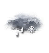
Night
3°Feels Like 2°
Gusts 20 km/hCalm
Overcast and misty. Limited visibility.
Light sleet.
Risk of rain
90 %
Share
CLIMATE info
Rain
+95%
normal
More rain than normal
Water restriction: No restrictions
Temperature
-1°C
normal
Colder than normal
Normal temperature : 6°C
Average, today :
5°C
One year ago : 6°C